Beginning today, people who have never been to Dickerson Park Zoo can take a tour without leaving their homes.
The same is true for 13 other parks and attractions thanks to the Google Maps Street View Trekker Project. Springfield was among the first destinations participating in the program and, so far, the only Missouri destination.
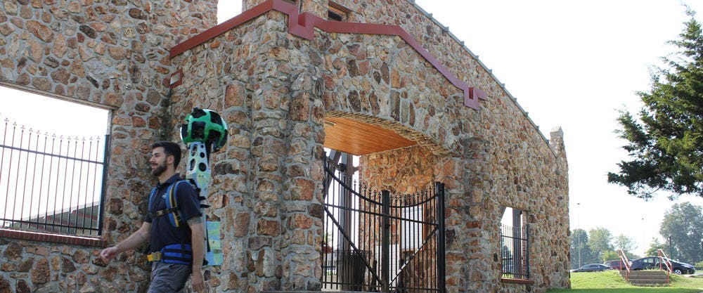
Google Maps loaned to the Convention & Visitors Bureau last year a backpack equipped with GPS technology, a computer and cameras that record 360-degree images. CVB staffers Sean Dixon, Walter Watts and Steve Ross “trekked” an estimated 30 miles with the 40-pound piece of equipment strapped on their backs and towering over their heads capturing imagery of the locations.
The result is 14 locations can now be viewed on Google Maps via panoramic images of places that can’t be accessed by the well-known Google Street View Car.
Melinda Arnold, public relations/marketing director at the zoo said she’s pleased the zoo is part of the project and potential visitors will be encouraged in this unique way to visit.
“We are honored that Dickerson Park Zoo was chosen as one of the Google video sites,” Arnold said. “This was a great opportunity for us to showcase our park and have great online content that benefits both the Convention & Visitors Bureau and the zoo.”
Locations that can be seen are:
- Valley Water Mill Park
- Springfield Conservation Nature Center
- Wilson's Creek National Battlefield
- Nathanael Greene Park
- Sequiota Park
- Doling Park
- Phelps Grove Park
- Jordan Valley Park
- Hammons Field
- Rutledge-Wilson Farm Park
- Mizumoto Japanese Stroll Garden
- Dickerson Park Zoo
- James River Water Trail
- Galloway Creek Greenway Trail

The Springfield Convention & Visitors Bureau team "trekked" over 30 miles of Springfield's parks, trails and waterways.
Three of the locations - the Mizumoto Japanese Stroll Garden, Hammons Field and the Springfield Conservation Nature Center - are also featured on the Google Maps U.S. Highlights page.
"From Nathanael Greene Park to Hammons Field, Springfield is full of incredible destinations,” said Deanna Yick, Google Maps Street View Program manager. “Now, these places are available for everyone around the world to see right in Google Maps, and be inspired to visit in person. Loaning our Trekker equipment to the Springfield Convention & Visitors Bureau was the best way to create a virtual experience of such a beautiful place."
The pilot project’s goal is to enhance Google Maps with panoramic images of places that can’t be accessed by the well-known Google Street View Car.
The project potentially exposes millions of Google Maps users to Springfield’s amazing assets in a unique, virtual way, said Dixon, who led the project in Springfield. The CVB hopes that access will encourage people who are not familiar with Springfield to visit the city. Along with appearing on Google Maps, links will show up in Google Search results. The CVB also plans to embed the imagery on its website.
“We’re always looking for new ways to tell the story of Springfield,” Dixon said. “The Google Trekker project gives us the opportunity virtually immerse potential visitors in attractions too large for any single photograph.”
Susan Wade, public relations manager for the CVB, said the project is exciting in part because it will generate publicity for the area during National Travel & Tourism Week May 2-10 when the CVB is conducting a variety of activities to increase awareness of the value of travel and tourism to Springfield.
“This is one more thing we can promote,” said Wade. “Along with potential visitors seeing the imagery and being encouraged to visit the city, we hope local people will gain a better understanding of the importance of the travel and tourism industry in Springfield.”


